University of Minnesota
http://www.umn.edu/
612-625-5000
http://www.umn.edu/
612-625-5000
Minnesota Biodiversity Atlas
Bell Museum
Dataset: MIN-Plants
Taxa: Amelanchier alnifolia
Search Criteria: excluding cultivated/captive occurrences
1
Page 1, records 1-75 of 75
Bell Museum plants | |
 MIN:Plants | 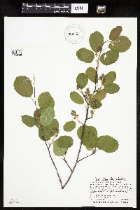 Amelanchier alnifolia var. alnifolia (Nuttall) Nuttall ex M. Roemer 902952[1023526]Smith, Welby 278081999-05-28 United States, Minnesota, Marshall, Marshall County...Old Mill State Park, about 11 miles west of Newfolden...T156N R46W NW1/4 of SW1/4 of Sec 4;Old Mill State Park;156N;46W;04, 48.362513 -96.576233 |
MIN:Plants |  Amelanchier alnifolia var. alnifolia (Nuttall) Nuttall ex M. Roemer 902954[1023525]Smith, Welby 277341999-05-13 United States, Minnesota, Marshall, Marshall County...About 6 miles N-NE of Newfolden...T157N R44W SE1/4 of SE1/4 of Sec 2;;157N;44W;02, 48.449599 -96.288196 |
MIN:Plants | 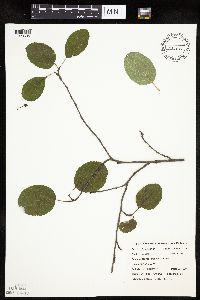 Amelanchier alnifolia var. alnifolia (Nuttall) Nuttall ex M. Roemer 477804[1023505]Belanger, W. 3311999-07-14 United States, Minnesota, Morrison, Crane Meadows National Wildlife Refuge ... NENE 30-40-31 ... FQURU1-02 Q4-Q1;Crane Meadows National Wildlife Refuge;040N;31W;30, 45.9338958 -94.2515644 |
MIN:Plants | Amelanchier alnifolia (Nuttall) Nuttall ex M. Roemer 479920[]US Nat. Arboretum staff 1661978-00-00 Canada, British Columbia, [no further data] |
MIN:Plants | 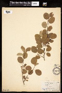 Amelanchier alnifolia var. alnifolia (Nuttall) Nuttall ex M. Roemer 125795[1023532]Moyer, Lycurgus 3461913-06-22 United States, Minnesota, Chippewa, Montevideo;;117N;40W;, 44.9425 -95.72333 |
MIN:Plants | 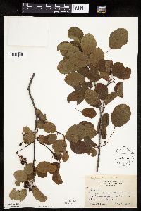 Amelanchier alnifolia var. alnifolia (Nuttall) Nuttall ex M. Roemer 293636[1023511]Nielsen, E. 23131933-06-27 United States, Minnesota, Becker, Muensch's farm near Long Lake, Detroit Lakes.;;139N;41W;, 46.84756 -95.85862 |
MIN:Plants | 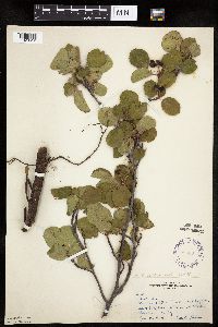 Amelanchier alnifolia var. alnifolia (Nuttall) Nuttall ex M. Roemer 293691[1023512]Nielsen, E. 27221934-06-20 United States, Minnesota, Becker, between Lake Munson and Long Lake, Detroit Lakes;;138N;41W;, 46.81722 -95.845 |
MIN:Plants | 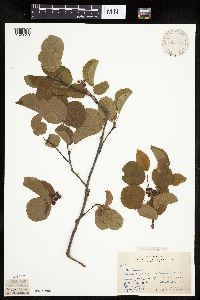 Amelanchier alnifolia var. alnifolia (Nuttall) Nuttall ex M. Roemer 293695[1023510]Nielsen, E. 21181933-07-05 United States, Minnesota, Becker, near State Fish Hatchery, Detroit Lakes, Becker County near State Fish Hatchery, Detroit Lakes. , 46.81722 -95.845 |
MIN:Plants | 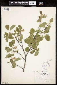 Amelanchier alnifolia var. alnifolia (Nuttall) Nuttall ex M. Roemer 298476[1023519]Zeck, Otto 3061935-05-31 United States, Minnesota, Becker, Sec.30, Erie Twp, Detroit Lakes, Becker Co.;;139N;;, 46.84722 -95.735 |
MIN:Plants | 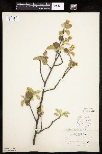 Amelanchier alnifolia var. alnifolia (Nuttall) Nuttall ex M. Roemer 298499[1023518]Zeck, Otto 2991935-05-29 United States, Minnesota, Becker, W of Ben Hammin's farm, Height of Land Twp, Becker Co.;;139N;39W;, 46.8925 -95.61 |
MIN:Plants | 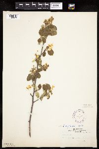 Amelanchier alnifolia var. alnifolia (Nuttall) Nuttall ex M. Roemer 298514[1023513]Zeck, Otto 2741935-05-25 United States, Minnesota, Becker, Sec.30, Erie Twp, Detroit Lakes, Becker Co.;;139N;40W;30, 46.8253 -95.78492 |
MIN:Plants | 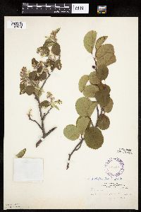 Amelanchier alnifolia var. alnifolia (Nuttall) Nuttall ex M. Roemer 298516[1023514]Zeck, Otto 2761935-05-25 United States, Minnesota, Becker, Sec.30, Erie Twp, Detroit Lakes, Becker Co.;;139N;40W;30, 46.8253 -95.78492 |
MIN:Plants | 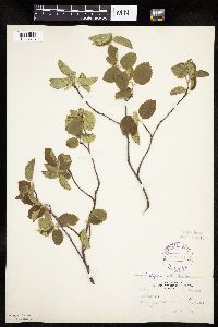 Amelanchier alnifolia var. alnifolia (Nuttall) Nuttall ex M. Roemer 298521[1023516]Zeck, Otto 2821935-05-26 United States, Minnesota, Becker, SW of bridge, Height of Land Lake, Becker Co.;Tamarac National Wildlife Refuge;140N;39W;, 46.89167 -95.60639 |
MIN:Plants | 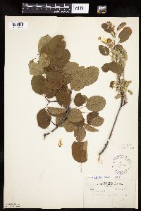 Amelanchier alnifolia var. alnifolia (Nuttall) Nuttall ex M. Roemer 298529[1023517]Zeck, Otto 2881935-05-27 United States, Minnesota, Becker, Sec 30, Erie Twp, Becker Co.;;139N;40W;30, 46.8253 -95.78492 |
MIN:Plants | 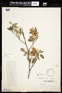 Amelanchier alnifolia var. alnifolia (Nuttall) Nuttall ex M. Roemer 298530[1023515]Zeck, Otto 2801935-05-26 United States, Minnesota, Becker, SW of bridge, Height of Land Lake, Becker Co.;Tamarac National Wildlife Refuge;140N;39W;, 46.89167 -95.60639 |
MIN:Plants | 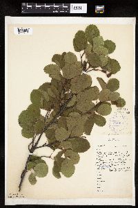 Amelanchier alnifolia var. alnifolia (Nuttall) Nuttall ex M. Roemer 304802[1023509]Nielsen, E. 13951932-07-06 United States, Minnesota, Otter Tail, 3 mi N Pelican Rapids, on hwy to Detroit Lakes, just N of Prairie Lake;;;;, 46.61426 -96.08278 |
MIN:Plants |  Amelanchier alnifolia var. alnifolia (Nuttall) Nuttall ex M. Roemer 304803[1023508]Nielsen, E. 13941932-07-06 United States, Minnesota, Otter Tail, 3 mi. N of Pelican Rapids on Hwy. to Detroit Lakes. Just N of Prairie Lakes.;;;;, 46.61426 -96.08278 |
MIN:Plants | 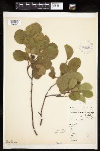 Amelanchier alnifolia var. alnifolia (Nuttall) Nuttall ex M. Roemer 304805[1023507]Nielsen, E. 13921932-07-06 United States, Minnesota, Becker, Long Lake, Detroit Lakes;;139N;41W;, 46.84756 -95.85862 |
MIN:Plants | 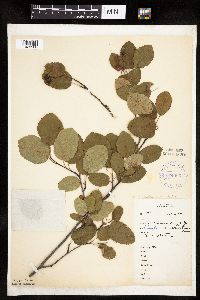 Amelanchier alnifolia var. alnifolia (Nuttall) Nuttall ex M. Roemer 304806[1023506]Nielsen, E. 13901932-07-06 United States, Minnesota, Becker, Detroit Lakes;;139N;41W;, 46.81722 -95.845 |
MIN:Plants | 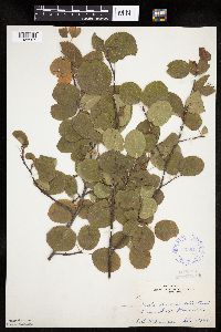 Amelanchier alnifolia var. alnifolia (Nuttall) Nuttall ex M. Roemer 333611[1023537]Cooper, William 81929-09-13 United States, Minnesota, Crow Wing, Brainerd 140;;;;, 46.35806 -94.20056 |
MIN:Plants | 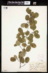 Amelanchier alnifolia var. alnifolia (Nuttall) Nuttall ex M. Roemer 364523[1023521]Stork, H. 20901926-10-07 United States, Minnesota, Rice, Blueberry Glen, Northfield;;;;, 44.45833 -93.16139 |
MIN:Plants | Amelanchier alnifolia var. alnifolia (Nuttall) Nuttall ex M. Roemer 405391[]Lakela, Olga 80531949-05-21 United States, Minnesota, Saint Louis, Terrace of Prairie Lake, southwest area of county.;;050N;20W;29, 46.79124 -92.904888 |
MIN:Plants | 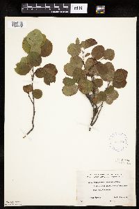 Amelanchier alnifolia var. alnifolia (Nuttall) Nuttall ex M. Roemer 407788[1023534]Lakela, Olga 98531949-09-14 United States, Minnesota, Saint Louis, White Iron Lake near Ely;Superior National Forest;062N;12W;, 47.84605 -91.86099 |
MIN:Plants | 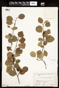 Amelanchier alnifolia var. alnifolia (Nuttall) Nuttall ex M. Roemer 412306[1023523]Moore, John; et al. 116071939-08-09 United States, Minnesota, Kittson, Near the W line of Sec. 3, Richardville Twp. Kittson Co.;;163N;48W;03, 48.94694 -96.86222 |
MIN:Plants | 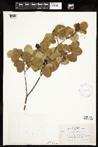 Amelanchier alnifolia var. alnifolia (Nuttall) Nuttall ex M. Roemer 419931[1023535]Lakela, Olga 108141950-07-24 United States, Minnesota, Saint Louis, Pequawan Lake Road, S of Rollins, E St. Louis Co.;;;;, 47.25667 -91.845 |
MIN:Plants | 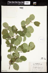 Amelanchier alnifolia var. alnifolia (Nuttall) Nuttall ex M. Roemer 421155[1023536]Lakela, Olga 111731950-08-28 United States, Minnesota, Saint Louis, Savanna River woods, at the end of the road, Hwy 29, W of Floodwood;;;;, 46.92917 -92.91944 |
MIN:Plants | 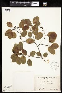 Amelanchier alnifolia var. alnifolia (Nuttall) Nuttall ex M. Roemer 437114[1023538]Moore, John; et al. 121961939-08-28 United States, Minnesota, Roseau, 3 mi. W of Warroad on Hwy. 11.;;;;, 48.90526 -95.38022 |
MIN:Plants | 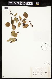 Amelanchier alnifolia var. alnifolia (Nuttall) Nuttall ex M. Roemer 443094[1023530]Lakela, Olga 130641951-07-11 United States, Minnesota, Saint Louis, ca 4 mi from Kettle Falls, Rainy Lake area;;;;, 48.49944 -92.63889 |
MIN:Plants |  Amelanchier alnifolia var. alnifolia (Nuttall) Nuttall ex M. Roemer 524491[1023529]Benner, J. 4551929-05-12 United States, Minnesota, Goodhue, Wacouta Beach, near Lake Pepin;;113N;14W;, 44.54583 -92.41028 |
MIN:Plants |  Amelanchier alnifolia var. alnifolia (Nuttall) Nuttall ex M. Roemer 526372[1023503]Moore, John 210591951-06-26 United States, Minnesota, Todd, 5 mi S of Bertha;;;;, 46.19428 -95.0625 |
MIN:Plants |  Amelanchier alnifolia var. alnifolia (Nuttall) Nuttall ex M. Roemer 554516[1023520]Moore, John 230891957-05-28 United States, Minnesota, Clay, 6 1/2 mi E of Barnesville;;;;, 46.65221 -96.37726 |
MIN:Plants | Amelanchier alnifolia var. alnifolia (Nuttall) Nuttall ex M. Roemer 566532[]Moore, John 238761958-06-12 United States, Minnesota, Kittson, 8 mi. north east of Lancaster;;;;, 48.94011 -96.679788 |
MIN:Plants |  Amelanchier alnifolia var. alnifolia (Nuttall) Nuttall ex M. Roemer 566568[1023501]Moore, John 239551958-06-16 United States, Minnesota, Kittson, along river, 1 1/2 mi N of Hallock;;;;, 48.80338 -96.94611 |
MIN:Plants | 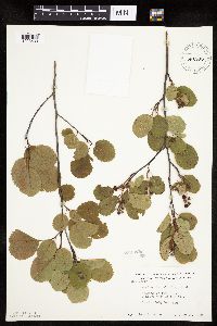 Amelanchier alnifolia var. alnifolia (Nuttall) Nuttall ex M. Roemer 585693[1023533]Moore, John 260671962-06-27 United States, Minnesota, Kittson, 3 mi E of Hallock;;;;, 48.77442 -96.88023 |
MIN:Plants | 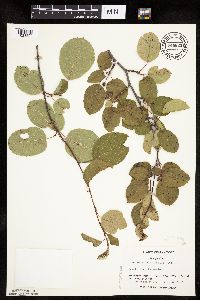 Amelanchier alnifolia var. alnifolia (Nuttall) Nuttall ex M. Roemer 744625[1023504]Converse, C. 12491982-06-22 United States, Minnesota, Douglas, Staffanson Prairie: T127N, R40W, NW1/4 NE1/4 and NE1/4 NW1/4 of S18;Staffanson Prairie, The Nature Conservancy;127N;40W;18, 45.810665 -95.7480052 |
MIN:Plants | 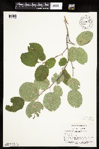 Amelanchier alnifolia var. alnifolia (Nuttall) Nuttall ex M. Roemer 744676[1023539]Converse, C. 22971982-08-25 United States, Minnesota, Pope, Moe Woods: T123N, R36W, SE1/4 SW1/4 S34;Moe Woods, The Nature Conservancy;123N;36W;34, 45.4198101 -95.1833376 |
MIN:Plants | 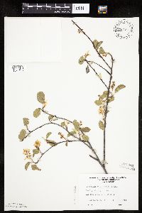 Amelanchier alnifolia var. alnifolia (Nuttall) Nuttall ex M. Roemer 756154[1023498]Converse, C. 23381983-05-24 United States, Minnesota, Benton, Benton Co. SE1/4 NE1/4 S35, T38N, R31W;;038N;31W;35, 45.74295 -94.16402 |
MIN:Plants |  Amelanchier alnifolia var. alnifolia (Nuttall) Nuttall ex M. Roemer 807694[1023531]Dorio, J. 3421977-06-23 United States, Minnesota, Benton, Benton Co. Englund Ecotone;Englund Ecotone, The Nature Conservancy;037N;31W;, 45.69547 -94.17241 |
MIN:Plants |  Amelanchier alnifolia var. alnifolia (Nuttall) Nuttall ex M. Roemer 807712[1023502]Dorio, J. 531977-05-26 United States, Minnesota, Morrison, Ripley Esker;Ripley Esker Scientific Natural Area;042N;31W;, 46.1136333 -94.2508846 |
MIN:Plants |  Amelanchier alnifolia var. alnifolia (Nuttall) Nuttall ex M. Roemer 807726[1023500]Dorio, J. 131977-05-23 United States, Minnesota, Morrison, Co.: Morrison ... Sandhill Crane Meadow, T39N R31W Sec. 3 & 4;Crane Meadows National Wildlife Refuge;039N;31W;, 45.9044 -94.18858 |
MIN:Plants |  Amelanchier alnifolia var. alnifolia (Nuttall) Nuttall ex M. Roemer 814747[1023522]Wheeler, Gerald 111031988-07-16 United States, Minnesota, Traverse, Traverse Co.; Browns Valley (NE side); W of Rte 2, bluffs bordering creek, NW1/4 NW1/4 S34, T125N, R49W (Folsom Twp);;125N;49W;34, 45.6225 -96.79194 |
MIN:Plants | 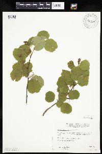 Amelanchier alnifolia var. alnifolia (Nuttall) Nuttall ex M. Roemer 814818[1023499]Wheeler, Gerald 104761988-05-25 United States, Minnesota, Norman, Norman County...Ca 9 mi NNE of Gary; wildlife area N of road, near a small lake, E1/2 SW1/4 S6, T146N, R43W;Ranum Wildlife Management Area;146N;43W;06, 47.49246 -96.18495 |
MIN:Plants | 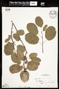 Amelanchier alnifolia (Nuttall) Nuttall ex M. Roemer 680282[1023540]Bright, R. 74-2211974-09-12 United States, Idaho, Franklin, Franklin Co, Hillyard Canyon about half way up ... 12 miles east of Preston.;;;;, 42.13833 -111.63472, 2134m |
MIN:Plants | 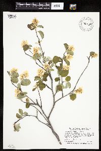 Amelanchier alnifolia var. alnifolia (Nuttall) Nuttall ex M. Roemer 902967[1023524]Smith, Welby 269751998-05-04 United States, Minnesota, Polk, Polk County...Winger National Waterfowl Production Area, about 2 mi N-NE of Winger...T147N R42W SE1/4 of SE1/4 of Sec 11;Winger Wildlife Area;147N;42W;11, 47.564403 -95.971232 |
MIN:Plants | 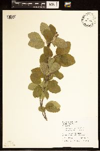 Amelanchier alnifolia var. alnifolia (Nuttall) Nuttall ex M. Roemer 454701[1283672]Juhnke, C. 173 CMJ FRO1999-05-05 United States, Minnesota, Goodhue, Atop bluff north of contact station. NW SE NW of section.;Frontenac State Park;112N;13W;02, 44.507468 -92.326291 |
MIN:Plants | Amelanchier alnifolia (Nuttall) Nuttall ex M. Roemer 479918[]Bright, R. 73-3441973-00-00 United States, Idaho, Franklin, [no further data] |
MIN:Plants | 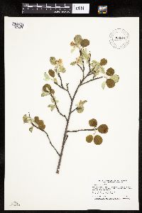 Amelanchier alnifolia var. alnifolia (Nuttall) Nuttall ex M. Roemer 902971[1023528]Smith, Welby 256171995-05-16 United States, Minnesota, Lyon, Lyon County...Camden State Park, about 10 miles southwest of Marshall...T110N R42W NE1/4 of SE1/4 of Sec 5;Camden State Park;110N;42W;05, 44.36 -95.9172222 |
MIN:Plants | Amelanchier alnifolia (Nuttall) Nuttall ex M. Roemer 479919[]Bright, R. 71-81971-00-00 United States, Idaho, Bannock, [no further data] |
MIN:Plants | 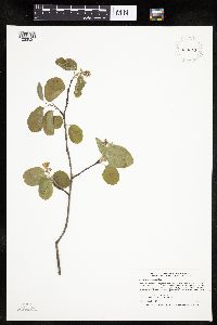 Amelanchier alnifolia var. alnifolia (Nuttall) Nuttall ex M. Roemer 923311[1023527]Smith, Welby 201701992-05-19 United States, Minnesota, Red Lake, About 6 miles W of Red Lake Falls. Above the Red Lake River. NW1/4 of SW1/4 of section.;Huot Wildlife Management Area;151N;45W;27, 47.870727 -96.396152 |
MIN:Plants | 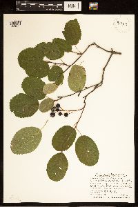 Amelanchier alnifolia var. alnifolia (Nuttall) Nuttall ex M. Roemer 935465[1283673]Smith, Welby R. 331312011-08-02 United States, Minnesota, Koochiching, About 10 miles E-NE of Craigville. SE of NE of section;Koochiching State Forest;063N;24W;16, 47.9450167 -93.4042833 |
MIN:Plants | 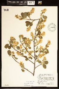 Amelanchier alnifolia var. alnifolia (Nuttall) Nuttall ex M. Roemer 902966[1283667]Smith, Welby R. 269981998-05-05 United States, Minnesota, Pennington, about 2 miles west of St. Hilary. NE1/4 of NE1/4 of Sec.;Higenbotham Wildlife Management Area;152N;44W;09, 48.0052778 -96.3025 |
MIN:Plants | 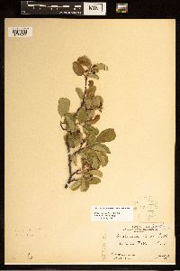 Amelanchier alnifolia (Nutt.) Nutt. 228475[1283783]Rosendahl, C.; Butters, F. s.n.1920-06-19 United States, Wisconsin, Polk, St. Croix Falls;Saint Croix National Riverway;;;, 45.426173 -92.644787 |
MIN:Plants | 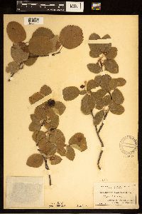 Amelanchier alnifolia (Nuttall) Nuttall ex M. Roemer 125797[1283801]Moyer, Lycurgus s.n.1911-07-02 United States, South Dakota, Roberts, Bluffs of Big Stone Lake |
MIN:Plants | 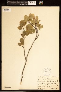 Amelanchier alnifolia var. alnifolia (Nuttall) Nuttall ex M. Roemer 301847[1283800]Keinholz, R. 2161929-09-05 United States, Minnesota, Big Stone, South of Chautauqua Park, Big Stone Lake;;;;, 45.409244 -96.610864 |
MIN:Plants | 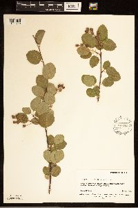 Amelanchier alnifolia (Nuttall) Nuttall ex M. Roemer 576722[1283799]Erdman, James 501959-06-16 United States, Colorado, Montezuma, Wetherill Mesa;Mesa Verde National Park, 2438m |
MIN:Plants |  Amelanchier alnifolia (Nuttall) Nuttall ex M. Roemer 392025[1283798]Duncan, W. s.n.1940-06-25 United States, South Dakota, Minnehaha, [no further data] |
MIN:Plants |  Amelanchier alnifolia (Nuttall) Nuttall ex M. Roemer 280124[1283797]Harris, J. Arthur C295161929-08-17 United States, Utah, Garfield, Between Bryce Canyon & Ruby's Inn;Bryce Canyon National Park |
MIN:Plants |  Amelanchier alnifolia (Nuttall) Nuttall ex M. Roemer 297358[1283796]Stoesz, A. s.n.1935-05-25 United States, North Dakota, Cass, S.E. of car stop, near Kindred. Station #21. |
MIN:Plants |  Amelanchier alnifolia (Nuttall) Nuttall ex M. Roemer 575399[1283795]Garton, C. 88541961-07-19 Canada, Ontario, Rainy River, 4 mi. N of Rainy River Town, Wildland Reserve.;;;;, 48.774554 -94.566667 |
MIN:Plants |  Amelanchier alnifolia (Nuttall) Nuttall ex M. Roemer 531597[1283794]Stevens, O. 16291956-00-00 United States, North Dakota, Cass, Fargo |
MIN:Plants | 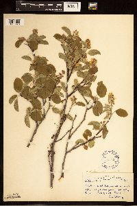 Amelanchier alnifolia (Nuttall) Nuttall ex M. Roemer 297356[1283793]Stoesz, A. s.n.1935-05-25 United States, North Dakota, Cass, Kindred. 4 feet east of tree#1. Station 21. Tree 2. |
MIN:Plants | 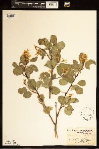 Amelanchier alnifolia (Nuttall) Nuttall ex M. Roemer 125867[1283792]Burglehaus, F. s.n.1894-06-06 United States, Wyoming, Park, Near Mammoth Hot Springs;Yellowstone National Park, 1219m |
MIN:Plants |  Amelanchier alnifolia (Nuttall) Nuttall ex M. Roemer 228294[1283784]Stork, H.; Stork, G. 561923-07-00 United States, Montana, [o further data];Glacier National Park |
MIN:Plants | 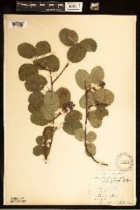 Amelanchier alnifolia (Nuttall) Nuttall ex M. Roemer 125769[1283791]Elmer, A.D.E. 25121900-07-00 United States, Washington, Clallam, Olympic Mts. [Olympic National Park] |
MIN:Plants | 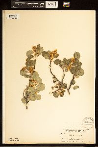 Amelanchier alnifolia (Nuttall) Nuttall ex M. Roemer 125814[1283790]Nelson, Aven; Nelson, Elias 55671899-06-29 United States, Wyoming, Park, Glen Creek;Yellowstone National Park |
MIN:Plants |  Amelanchier alnifolia (Nuttall) Nuttall ex M. Roemer 595620[1283789]Nielsen, E. s.n.1948-07-00 United States, North Dakota, Billings, just east of east entrance;Theodore Roosevelt National Park |
MIN:Plants |  Amelanchier alnifolia (Nuttall) Nuttall ex M. Roemer 595619[1283788]Nielsen, E. s.n.1948-07-00 United States, North Dakota, Billings, Medora (Stop 3);Theodore Roosevelt National Park |
MIN:Plants |  Amelanchier alnifolia (Nuttall) Nuttall ex M. Roemer 595618[1283787]Nielsen, E. s.n.1948-07-00 United States, North Dakota, Billings, Medora (Stop 4);Theodore Roosevelt National Park |
MIN:Plants |  Amelanchier alnifolia (Nuttall) Nuttall ex M. Roemer 580275[1283786]Badgley, Helen 531947-07-21 United States, Montana, Glacier, Mt. Running Rabbit;Glacier National Park, 1402m |
MIN:Plants |  Amelanchier alnifolia (Nuttall) Nuttall ex M. Roemer 490239[1283785]Bergman, H. s.n.1912-05-06 United States, North Dakota, Cass, Fargo |
MIN:Plants |  Amelanchier alnifolia (Nutt.) Nutt. ex M. Roem. 969392[1371011]Rowe, Erika R. ERR7722011-07-28 United States, Minnesota, Beltrami, Red Lake State Forest. 0.53 miles east of MN Trunk Hwy 72; 3 miles south-southeast of Waskish., 48.11 -94.5 |
MIN:Plants | Amelanchier alnifolia (Nutt.) Nutt. ex M. Roem. []Siegrist, J. GW13792002-07-29 United States, Colorado, Gunnison, Kebler Pass Road near Marcellina Mountain, Gunnison National Forest, Gunnison County, 38.910056 -107.240528, 2590m |
MIN:Plants | Amelanchier alnifolia (Nutt.) Nutt. ex M. Roem. []Garlo, K. GW22512003-07-24 United States, Colorado, Gunnison, mile 11 on Kebler Pass Road, 38.9 -107.233333, 2650m |
MIN:Plants | Amelanchier alnifolia (Nutt.) Nutt. ex M. Roem. []Grube, R. GW22632003-07-24 United States, Colorado, Gunnison, private property on Roatcap Creek near Panionan Reservoir, 38.916667 -107.4, 1859m |
MIN:Plants | Amelanchier alnifolia (Nutt.) Nutt. ex M. Roem. []Timothy J. S. Whitfeld 36752023-07-07 United States, Minnesota, Marshall, Huntley Management Area, 0.5 miles northwest of right angle turn of 130th Avenue NE, 48.45447 -96.19626, 354m |
1
Page 1, records 1-75 of 75
Google Map
Google Maps is a web mapping service provided by Google that features a map that users can pan (by dragging the mouse) and zoom (by using the mouse wheel). Collection points are displayed as colored markers that when clicked on, displays the full information for that collection. When multiple species are queried (separated by semi-colons), different colored markers denote each individual species.